|
| |||||
Calgary Playground
From Brooklyn Centre Wiki
(Difference between revisions)
| (17 intermediate revisions not shown.) | |||
| Line 1: | Line 1: | ||
[[Image:Calgary_Park.jpg|thumb|Calgary Park]] | [[Image:Calgary_Park.jpg|thumb|Calgary Park]] | ||
| + | [[Image:_map_1912_-_Bridgeview_allotments.jpg|thumb|Platmap showing Bridgeview Allotments 1 and 2. Calgary Park area as it appeared prior to purchase by the City of Cleveland.]] | ||
| + | [[Image:_1951_aerial_photo_-_Calgary.JPG|thumb|Aerial photograph of Calgary (1951)]] | ||
'''HISTORY:''' | '''HISTORY:''' | ||
| - | :The 5.25 acre Calgary Park Playground sits on land that is part of the Bridge View Park Allotment | + | :The 5.25 acre Calgary Park Playground sits on land that is part of the Bridge View Park Allotment #2 in [[Original Lot 64]] in Cuyahoga County, Ohio. It is bordered on the North by [[Calgary Avenue]]. |
| + | |||
| + | :Built by the Parks and Recreations department of the City of Cleveland in 1944.<ref>Information regarding the date the park was built, obtained from Joe Sidoti of the City Real Estate Department (216-664-4061). He was also able to provide the names of many of the property owners who sold their lots to the city for this park. Sublots involved were:<br>009-03-015 - 009-03-027<br>009-03-047 - 009-03-069</ref> | ||
:In the mid-20th century, it would sometimes be the site of a visit from the '''Show Wagon''', a form of traveling entertainment for children sponsored by the '''Cleveland Press'''. | :In the mid-20th century, it would sometimes be the site of a visit from the '''Show Wagon''', a form of traveling entertainment for children sponsored by the '''Cleveland Press'''. | ||
| - | :At the southernwestern end of the playground, one could follow a trail down the steep shale hill to gain access to the railroad tracks and which could be followed westerly to the [[Cleveland MetroPark Zoo]]. | + | :At the southernwestern end of the playground, one could follow a trail down the steep shale hill to gain access to the railroad tracks and which could be followed westerly to the [[Brookside Park Zoo|Cleveland MetroPark Zoo]]. The shale made for a slippery slope indeed and extra care would be needed to prevent sliding down the whole way or even worse, sliding off the steeper west side of the bluff which would land you in [[Big Creek]] if you survived the fall. |
| + | |||
| + | :An elderly woman, Jennie (Frydrych) Grega, said that her father, Stanley Frydrych, was in a band that played in a dance hall across the valley from where they lived (southern end of the Brooklyn Bridge). People would walk across the [[Big Creek]] valley and then follow a path up the hill to get to the dance hall. The question is: Were they going up the hill path that led to Calgary, or to some other hall? | ||
| + | |||
| + | :Mrs. Pawul, who lived at [[Wieland St.|West 24th St.]] and [[Selzer Avenue]], has a clear memory of the dancing, but it wasn't a permanent structure that existed at Calgary. Someone actually brought in a stage for the band to play on and a dance floor would be erected. So all the dancing was done outdoors. | ||
'''QUESTIONS:''' | '''QUESTIONS:''' | ||
| - | #What year was the park created? | ||
#Why was it named Calgary? | #Why was it named Calgary? | ||
| + | ::<font color="green">Apparently, the park was named for the street (Calgary Avenue) just to the north of it.</font> | ||
| + | |||
#Was the park named for the street? Or was the street named for the park? | #Was the park named for the street? Or was the street named for the park? | ||
| + | ::<font color="green">The park was named for the street. The earliest listing in a city directory that mentions Calgary was for the year 1936. Unfortunately, earlier directories didn't organize resident listings by street -- only alphabetically. Also, none of the sublots along the south side of Calgary Avenue fronted on that street. Each of the sublots either fronted on West 23rd or West 22nd Street.</font> | ||
| + | |||
| + | |||
| + | '''Chain of Ownership:''' | ||
| + | #William and Catherine Fuller. William died in 1885. | ||
| + | #Catherine Fuller dispersed the property to her son, Joel Fuller, son of the above. (see [[Fuller, Kain, and Kroehle]]). | ||
| + | #(1916) Joel Fuller sold to the Hanna Estate | ||
| + | #(1918) Hanna Estate sold to the [[Stewart Land Company|Stewart Company]] (AKA Stewart Land Company) | ||
| + | #(1920) Stewart Land Company sold to Jay Beckwith | ||
| + | #Distribution to City of Cleveland as follows | ||
| + | :West 23rd side: | ||
| + | ::Sublots / Owner<BR> | ||
| + | ::------------------------------------------------------------ | ||
| + | ::01-05 Stern, Gertrude apparently through some sort of settlement. | ||
| + | ::06-09 contained houses - not sold to city | ||
| + | ::10-17 Stern, Gertrude | ||
| + | |||
| + | :West 22nd side: | ||
| + | ::Sublots / Owner<BR> | ||
| + | ::------------------------------------------------------------ | ||
| + | ::18-22 Holl, George | ||
| + | ::23 Crisafi, Thomas | ||
| + | ::24-25 Holl, George | ||
| + | ::26-28 contained houses - not sold to city | ||
| + | ::29 Crisafi, Thomas | ||
| + | ::30-34 Arendt, Herman | ||
| + | ::35-37 Harrison, Jade | ||
| + | ::38-40 Holl, George | ||
| + | ::41 Meyer, William | ||
| + | ::42-43 Johanson, Karl (Carl) | ||
| + | |||
| + | |||
| + | ==Notes== | ||
| + | <references/> | ||
| + | |||
| + | |||
| + | <googlemap lat="41.44649" lon="-81.698434" type="map" zoom="15"> | ||
| + | 41.445839, -81.698413, Calgary Park | ||
| + | </googlemap> | ||
| + | |||
| + | |||
| + | {{back2main}} | ||
Current revision
HISTORY:
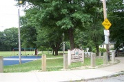
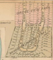
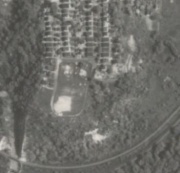
- The 5.25 acre Calgary Park Playground sits on land that is part of the Bridge View Park Allotment #2 in Original Lot 64 in Cuyahoga County, Ohio. It is bordered on the North by Calgary Avenue.
- Built by the Parks and Recreations department of the City of Cleveland in 1944.[1]
- In the mid-20th century, it would sometimes be the site of a visit from the Show Wagon, a form of traveling entertainment for children sponsored by the Cleveland Press.
- At the southernwestern end of the playground, one could follow a trail down the steep shale hill to gain access to the railroad tracks and which could be followed westerly to the Cleveland MetroPark Zoo. The shale made for a slippery slope indeed and extra care would be needed to prevent sliding down the whole way or even worse, sliding off the steeper west side of the bluff which would land you in Big Creek if you survived the fall.
- An elderly woman, Jennie (Frydrych) Grega, said that her father, Stanley Frydrych, was in a band that played in a dance hall across the valley from where they lived (southern end of the Brooklyn Bridge). People would walk across the Big Creek valley and then follow a path up the hill to get to the dance hall. The question is: Were they going up the hill path that led to Calgary, or to some other hall?
- Mrs. Pawul, who lived at West 24th St. and Selzer Avenue, has a clear memory of the dancing, but it wasn't a permanent structure that existed at Calgary. Someone actually brought in a stage for the band to play on and a dance floor would be erected. So all the dancing was done outdoors.
QUESTIONS:
- Why was it named Calgary?
- Apparently, the park was named for the street (Calgary Avenue) just to the north of it.
- Was the park named for the street? Or was the street named for the park?
- The park was named for the street. The earliest listing in a city directory that mentions Calgary was for the year 1936. Unfortunately, earlier directories didn't organize resident listings by street -- only alphabetically. Also, none of the sublots along the south side of Calgary Avenue fronted on that street. Each of the sublots either fronted on West 23rd or West 22nd Street.
Chain of Ownership:
- William and Catherine Fuller. William died in 1885.
- Catherine Fuller dispersed the property to her son, Joel Fuller, son of the above. (see Fuller, Kain, and Kroehle).
- (1916) Joel Fuller sold to the Hanna Estate
- (1918) Hanna Estate sold to the Stewart Company (AKA Stewart Land Company)
- (1920) Stewart Land Company sold to Jay Beckwith
- Distribution to City of Cleveland as follows
- West 23rd side:
- Sublots / Owner
- ------------------------------------------------------------
- 01-05 Stern, Gertrude apparently through some sort of settlement.
- 06-09 contained houses - not sold to city
- 10-17 Stern, Gertrude
- Sublots / Owner
- West 22nd side:
- Sublots / Owner
- ------------------------------------------------------------
- 18-22 Holl, George
- 23 Crisafi, Thomas
- 24-25 Holl, George
- 26-28 contained houses - not sold to city
- 29 Crisafi, Thomas
- 30-34 Arendt, Herman
- 35-37 Harrison, Jade
- 38-40 Holl, George
- 41 Meyer, William
- 42-43 Johanson, Karl (Carl)
- Sublots / Owner
Notes
- ↑ Information regarding the date the park was built, obtained from Joe Sidoti of the City Real Estate Department (216-664-4061). He was also able to provide the names of many of the property owners who sold their lots to the city for this park. Sublots involved were:
009-03-015 - 009-03-027
009-03-047 - 009-03-069
Help support this website by visiting some of the Ads provided by Google.


