|
| |||||
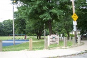
Calgary Playground
From Brooklyn Centre Wiki
(Difference between revisions)
| Line 14: | Line 14: | ||
#Was the park named for the street? Or was the street named for the park? | #Was the park named for the street? Or was the street named for the park? | ||
| - | <googlemap lat="41.44649" lon="-81.698434" type="map" zoom=" | + | |
| + | |||
| + | <googlemap lat="41.44649" lon="-81.698434" type="map" zoom="15"> | ||
41.445839, -81.698413, Calgary Park | 41.445839, -81.698413, Calgary Park | ||
</googlemap> | </googlemap> | ||
Revision as of 20:04, 17 February 2009
HISTORY:
- The 5.25 acre Calgary Park Playground sits on land that is part of the Bridge View Park Allotment at the north east corner of Original Lot #64 in Cuyahoga County, Ohio. It once belonged to William and Catherine Fuller. When William died in 1885, his wife dispersed the property to her son Joel (see Fuller, Kain, and Kroehle).
- In the mid-20th century, it would sometimes be the site of a visit from the Show Wagon, a form of traveling entertainment for children sponsored by the Cleveland Press.
- At the southernwestern end of the playground, one could follow a trail down the steep shale hill to gain access to the railroad tracks and which could be followed westerly to the Cleveland MetroPark Zoo. The shale made for a slippery slope indeed and extra care would be needed to prevent sliding down the whole way or even worse, sliding off the steeper west side of the bluff which would land you in Big Creek if you survived the fall.
QUESTIONS:
- What year was the park created?
- Why was it named Calgary?
- Was the park named for the street? Or was the street named for the park?

