|
| |||||
Brooklyn-Brighton Bridge
From Brooklyn Centre Wiki
(→HISTORY) |
(→HISTORY) |
||
| Line 4: | Line 4: | ||
The Brooklyn-Brighton Bridge provided a link between Brooklyn Centre on the north and Brighton Village (later known simply as Brooklyn or Old Brooklyn) on the south. The valley below had been difficult to travel by early settlers wanting to bring their goods to market in Cleveland. Driving oxen pulling a wagon laden with farm products would have been a challenge. The hills at either end of the valley were steep and hard enough for a human to walk up, much less for an animal with the burdens they were expected to pull. | The Brooklyn-Brighton Bridge provided a link between Brooklyn Centre on the north and Brighton Village (later known simply as Brooklyn or Old Brooklyn) on the south. The valley below had been difficult to travel by early settlers wanting to bring their goods to market in Cleveland. Driving oxen pulling a wagon laden with farm products would have been a challenge. The hills at either end of the valley were steep and hard enough for a human to walk up, much less for an animal with the burdens they were expected to pull. | ||
| - | It's hard to imagine it now, but the valley below the bridge was at one time farm land and a pasture for the | + | It's hard to imagine it now, but the valley below the bridge was at one time farm land and a pasture for the livestock of [[Moses Fish]] and his brother, [[Ebenezer Fish]]. It's very likely that their cousin, [[James Fish]], who lived just a short distance north of Ebenezer, also had his livestock graze down there. Decades later, the valley became more and more industrialized and the farm land was gone. |
==BRIDGE VERSIONS== | ==BRIDGE VERSIONS== | ||
Revision as of 15:01, 10 March 2009
HISTORY
The Brooklyn-Brighton Bridge provided a link between Brooklyn Centre on the north and Brighton Village (later known simply as Brooklyn or Old Brooklyn) on the south. The valley below had been difficult to travel by early settlers wanting to bring their goods to market in Cleveland. Driving oxen pulling a wagon laden with farm products would have been a challenge. The hills at either end of the valley were steep and hard enough for a human to walk up, much less for an animal with the burdens they were expected to pull.
It's hard to imagine it now, but the valley below the bridge was at one time farm land and a pasture for the livestock of Moses Fish and his brother, Ebenezer Fish. It's very likely that their cousin, James Fish, who lived just a short distance north of Ebenezer, also had his livestock graze down there. Decades later, the valley became more and more industrialized and the farm land was gone.
BRIDGE VERSIONS
Over the last two centuries, several bridges have been constructed in this same general location.
It is interesting to note that the concrete bridge built in 1916 is fully a thousand feet longer than the previous bridge. It is difficult now to imagine exactly where this earlier bridge's terminuses were that would account for that difference in length.
- pre-1887 - Small bridge spanning Big Creek
- 1887 to 1897 - Wooden bridge (dedicated 4 July 1887)
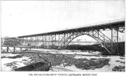
- 1897 to 1915 - Steel bridge
- The span consisted of a bridge 1,540 in length with a 29-1/2' roadway + 7' sidewalks on either side.[1] The road surface was wooden planking. Total cost including land was $170,000. Later condemned as unsafe.[2]
- 1916 - Concrete bridge
- The span consisted of a bridge 2,265' in length with a 76' wide roadway. Two streetcar tracks run along the center. Overall cost was a bit over half a million dollars.[3] Paved with Balfour Granite, commercial name "Durax Paving" of the Harris Granite Quarries Company of Salisbury, N.C.
References
- ↑ Types and Details of Bridge Construction, By Frank Woodward Skinner, 1904, page 118
- ↑ The Bridgemen's magazine, By International Association of Bridge and Structural Iron Workers, Indianapolis, Vol. XIII No.1, January 1913, pages 50 and 815
- ↑ Bridges of Cleveland and Cuyahoga County, 1918
Help support this website by visiting some of the Ads provided by Google.


