|
| |||||
Main Page
From Brooklyn Centre Wiki
(Difference between revisions)
(→External Links) |
|||
| Line 33: | Line 33: | ||
</div> | </div> | ||
| - | :Aerial view from [http://terraserver-usa.com/image.aspx? | + | :Aerial view from [http://terraserver-usa.com/image.aspx?T=1&S=11&Z=17&X=1105&Y=11472&W=2 Terraserver] |
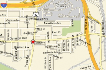
:Street map from [http://maps.yahoo.com/maps_result?addr=hurley&csz=cleveland%2C+oh&country=us&new=1&name=&qty= Yahoo Maps] | :Street map from [http://maps.yahoo.com/maps_result?addr=hurley&csz=cleveland%2C+oh&country=us&new=1&name=&qty= Yahoo Maps] | ||
| Line 39: | Line 39: | ||
| | | | ||
<div style="margin:0;background-color:lightyellow;border:1px solid #a3bfb1;text-align:left;color:#000;padding:0.2em 0.4em;"> | <div style="margin:0;background-color:lightyellow;border:1px solid #a3bfb1;text-align:left;color:#000;padding:0.2em 0.4em;"> | ||
| + | |||
===Pages Recently Added=== | ===Pages Recently Added=== | ||
</div> | </div> | ||
Revision as of 09:49, 10 June 2007
Today is: April 28, 2024
| 
|
The heart of Brooklyn Centre is at the intersection of West 25th Street and Denison Avenue in Cleveland, Ohio.
First settled in the early 1800's, it's history hasn't often been the focus of interest for Cleveland historians, who pay more attention to what happened on the east side of the Cuyahoga River. Nevertheless, this area has it's own story that shouldn't be overlooked or forgotten.
|
|
The Brooklyn Centre WIKI is a work in progress. Check back often to catch the latest updates.
