From Brooklyn Centre Wiki
West 13th, West 14th, West 15th, and Redman
1949 Aerial view of the Barbarowa Neighborhood
|
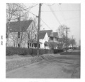
West 13th St. - Looking south from Redman [About 1960]
|
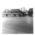
West 13th St. - Tillie Kuczek's store at 3701 W13th
|
Redman Ave. - northside from W14th to W13th
|
Redman Ave. - southside from W14th to W13th
|
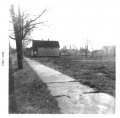
Foster Ct. - Alley between W.13th & W.14th looking north
|
Foster Ct. - western end of the alley looking southeast
|
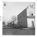
West 14th St. and Denison looking north
The vantage point is from the old Gulf Gas Station. Gasior's Bar is on the left corner. To the left of Gasior's can be seen a white house that was the home of George Foster, son of the original settler / landowner Ebenezer Foster of this side of Denison Ave.
|
West 14th St. and Denison looking north
The vantage point is about 3 houses from the corner of Denison and 14th. The brown house in the distance was on Redman Ave.
|
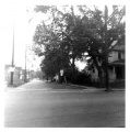
West 14th St. looking south from Redman Ave. towards Denison Ave. (Before the Jennings Freeway.)
|
West 14th St. looking south from Redman Ave. towards Denison Ave. (Before the Jennings Freeway.)
|
West 15th St. looking north from Denison Ave. The house on the right is the Kilroy home.
|
City Dump and Redman Woods
City Dump - Facing north (just north of Denison Ave. and west of West 15th) The rubbish that was dumped here served as a landfill. Originally, there was a deep ravine between Riverside Cemetery and the property on West 15th Street
|
City Dump - Facing northwest (City Hospital) (just north of Denison Ave. and west of West 15th)
|
Redman Woods - Facing east. The woods were between Jennings Ave. and Redman Ave. and belonged to Riverside Cemetery
|
Redman Woods - Facing south. The woods were between Jennings Ave. and Redman Ave. and belonged to Riverside Cemetery
|
Redman Woods - Mystery wall. This odd stone wall was on the northern part of the Redman woods. We never have been able to figure out why. Riverside Cemetery was probably planning to span the ravine with a bridge to allow vehicle traffic from one side to the other.
|
Denison Ave., Jennings Ave.
How Denison hill would have looked in the 1800's. This image isn't really Denison hill. The view was actually from Zanesville, but the resemblance was so strong, that it helps give you an idea of what might have been.
|
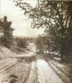
Denison Ave. hill down to Jennings Ave. Note the long wooden stairway that helped pedestrians get from the top of the hill to the bottom.
|
Denison Ave. and West 14th looking west.
-- On the right is the bakery that was operated as early as 1936 by Stanley Mankowski and then for a short time in 1942 by Frank Samosky (brother of the Samosky who ran the bakery near Fleet Ave.) and later by Frank Staszewski from 1942 into the mid-1950's. He died in 1957.
-- On the left, labeled as 1409 Denison is the large block building that was owned by John and Mary Oprzadek.
-- (City Hall Photograph Collection at the Cleveland Public Library)
|
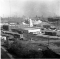
Belt Line Rd. showing some of the factories that were present around 1960. In the decades preceeding, many of the Polish immigrants of the neighborhood worked in the tanning mills or soap works that existed there back then.
|
Belt Line Rd. looking north (taken from the Harvard-Denison Bridge)
|
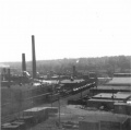
Factories in the Jennings and Denison Aves. area.
|
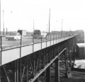
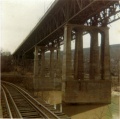
Harvard-Denison Bridge
Early photo of the Harvard-Denison bridge. Probably taken around 1910. Note the absence of factories. The view is to the northeast. The stairs down to Jennings Avenue can be seen a little more than halfway down the bridge.
|
|
Looking east (circa 1964)
|
Stairway that led from the bridge deck down to Jennings Avenue
|
Looking east - #18 CTS Bus
|
Swampy area under the Harvard-Denison Bridge (about 1964)
|
|
Jennings Freeway Demolition
West 14th St. looking south from Redman. The State shows no mercy for the condemned neighborhood. This view taken in 1964 shows part of the houses already torn down for the Jennings Freeway.
|
West 14th St. looking south from Redman. This view taken in 1964 shows the same area after it was cleaned up a bit.
|
West 15th St. and Redman looking west. Demolition has started. Watch the small house on the left. Next picture shows what happens.
|
West 15th St. and Redman looking west. Breaking thru...
|
West 15th St. and Redman looking west. CRASH!!!!
|
1230 Redman Ave. A shell of it's former self.
|
|
1314 Redman Ave. Also a shell of it's former self.
|
Denison Ave. looking east. The vantage point is the East Denison playground sidewalk that led into the open lot on the corner of W.15th and Denison. You are looking out across what used to be Kilroy's house, the bakery, and Gasior's Bar. All gone now. The building just left of center is Slabe's Shoe Store with the Harvard-Denison Bridge just right of that.
|
Miscellaneous
- Photos wanted! Please submit any you might have for the Brooklyn Centre area to barbarowa@yahoo.com
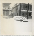
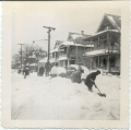
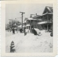
Scene on Redman Ave. (or possibly at 3706 W.13th) just after the great 1950 snowstorm.
(Submitted by Sally Kalemba)
|
Scene on Redman Ave. just after the great 1950 snowstorm. Houses in the foreground are (right to left) 1226, 1230, and 1302 Redman.
(Submitted by Sally Kalemba)
|
Scene on Redman Ave. just after the great 1950 snowstorm. Houses in the foreground are (right to left) 1226, 1230, and 1302 Redman.
(Submitted by Sally Kalemba)
|
"...the quoted material is entered here and should appear in italics."
--BOOK TITLE by The Distinguished Author's Name
The 1951 city directory shows who may have lived in the houses shown in the snowstorm picture:
- 1226 Umerley Leo J jr
- 1226 Walczesky Edw
- 1230 Andreasik Louis J
- 1230 Kimall Richd C (this should really be Richard KIMBALL)
- 1302 Chmura Bernard S
- 1302 Dzierzawski Theo H
One has to assume that the snow shovelers were probably residents of those houses since they were obviously trying to dig out that buried car.
I know nothing about Umerley.
Walczesky was married to a Czarnecki, though I'm not sure if she was related to the Czarnecki's on W.13th street or not. If so, there were plenty of Czarnecki boys to lend a hand.
Andreasik would have been 48 in 1950 and none of the shovelers look that old. Same with Kimball (they misspelled his name in the city directory) -- he was 47. He happened to die just a few months later of a heart attack, so I wonder if he would have even attempted to shovel snow if he knew he had heart problems?
Bernard Chmura was 26 and very likely one of the guys out there. Right age.
So somewhere in the above information is likely the answer. Maybe one day someone from those families will stumble across the pictures and recognize the faces and write to me. We can only hope..... :)
West 25th St.
- Photos wanted! Please submit any you might have for the Brooklyn Centre area to barbarowa@yahoo.com
Return to Photo Albums or
Return to Main Page
Help support this website by visiting some of the Ads provided by Google.


